
France’s ability to act as a resident maritime power in the Southwest Indian Ocean rests on a scattered constellation of tiny territories known in French as the Îles Éparses (Scattered Islands). These five islets—Tromelin in the open Indian Ocean and, in the Mozambique Channel, the Glorioso Islands, Juan de Nova, Bassas da India and Europa—add only 43 km² of land but unlock roughly 640 400 km² of maritime zones under French jurisdiction. In practice, they extend the country’s presence and responsibilities alongside Réunion and Mayotte, under the administration of the Terres australes et antarctiques françaises (TAAF). While Madagascar and Mauritius dispute parts of this archipelago, the Éparses function today as platforms for maritime governance, scientific research and conservation, and as a legal‑operational anchor for French patrols in a strategic seaway.

Why the Scattered Islands matter to France’s posture in the Indian Ocean
Geography and status within TAAF
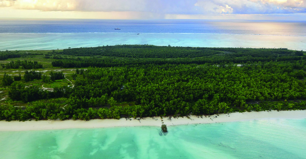
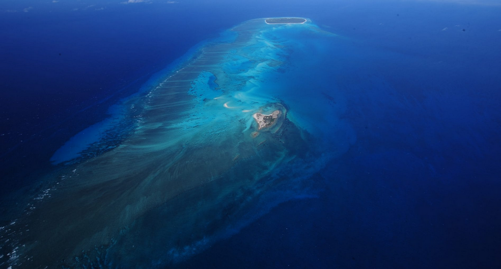
Set across hundreds of nautical miles—from about 10° to 25° S—the five entities are uninhabited, water‑scarce, and difficult to access. Since 2005 they have been managed day‑to‑day by the TAAF administration headquartered in Réunion, which exercises state functions (customs, fisheries control, environment and policing) and hosts rotating detachments for upkeep and security. Their administrative status consolidates French continuity of governance while allowing the islands to be integrated into national frameworks for protected areas and maritime surveillance.
Exclusive Economic Zones and shipping lanes in the Mozambique Channel
Despite their minute landmass, the Scattered Islands generate outsized maritime spaces—an estimated 640 400 km² when combining territorial seas and Exclusive Economic Zones (EEZs). In the Mozambique Channel alone, the EEZs associated with Europa, Juan de Nova, Bassas da India and the Gloriosos amount to roughly 355 600 km², or about 40 % of the channel’s surface; more than half if Mayotte’s EEZ is included. This maritime footprint underwrites French responsibilities for safety of navigation, fisheries management and environmental stewardship along a route that links Europe and Asia via the Cape of Good Hope whenever Suez is unavailable. Regional cabotage remains intense, and when the Suez Canal closed (1967–1975) or was blocked (notably in 2021), the Channel’s relevance to global flows was starkly illustrated.
Science stations, protected areas and the FAZSOI footprint
The islands are national nature reserves and, in some cases, marine parks, reflecting their exceptional biodiversity and low human footprint. Environmental rules—such as bans on fishing in territorial seas and closures around features like the Geyser Bank—couple with seasonal high‑seas tuna fisheries managed through the Indian Ocean Tuna Commission (IOTC). On the security side, presence is ensured through the Forces armées de la zone sud de l’océan Indien (FAZSOI), including periodic rotations of small detachments and naval/air patrols for law enforcement, search and rescue (SAR) support, and maritime domain awareness.
From decolonisation to dispute: what Paris and Antananarivo each claim
UN‑era legacies and competing legal frames
Sovereignty over Tromelin is contested by Mauritius, and Madagascar claims Juan de Nova, Europa, Bassas da India and the Gloriosos. The legal narratives differ. France emphasises administrative continuity and distinct treatment of the islets prior to Madagascar’s independence, culminating in their separate placement under metropolitan authority before 1960 and later integration into TAAF. Madagascar frames the issue as one of territorial integrity left unresolved by decolonisation. These positions have recurred at the United Nations and African fora for decades, with phases of diplomatic engagement and dormancy.
Diplomatic episodes and the 2019 joint commission
Intermittent bilateral efforts have sought to cool the dispute, including the establishment of a joint commission in 2019 aimed at exploring functional cooperation (scientific research, environmental protection, fisheries control) while the sovereignty question remained open. Progress has been limited, and domestic politics in both countries periodically raise the salience of the issue, constraining room for compromise and sustaining a low‑level stalemate.
Presence through practice: law enforcement, SAR and maritime governance
Fisheries control, anti‑trafficking patrols and maritime domain awareness
French jurisdiction across the Éparses EEZs enables day‑to‑day governance at sea: licensing and monitoring of offshore tuna fisheries, interdiction of illegal, unreported and unregulated (IUU) fishing, and suppression of trafficking. Regular patrols by patrol vessels and maritime surveillance aircraft help deter illicit activity in a vast space that is inherently difficult to police. The size and dispersion of these zones make cooperation with regional partners essential, from information‑sharing with coastal states to coordination with international fisheries bodies.
SAR coverage, meteorology and scientific data as public goods
Beyond enforcement, the islands support public‑good functions. Simple airstrips and meteorological or research installations contribute to regional SAR coverage, marine weather services and long‑term scientific baselines on climate and biodiversity. In remote waters prone to cyclones and seasonal monsoonal dynamics, such capabilities help underpin navigation safety and resilience for coastal communities and shipping alike.
What is stuck with Madagascar: sovereignty, resources and politics
Red lines on sovereignty and options for joint management
The dispute intertwines questions of principle and tangible interests. Conservation rules and France’s 2020 decision not to renew offshore hydrocarbon exploration near Juan de Nova have reduced immediate resource pressures, yet perceived prospective value—whether hydrocarbons, seabed minerals or simply future bargaining leverage—keeps claims alive. Joint management models have been discussed in abstract, but sovereignty remains a bright red line for both sides, and legal pathways to adjudication involve complexity, consent and long timelines. In the meantime, pragmatic cooperation on science, conservation and fisheries could provide incremental benefits without prejudicing claims.
Domestic opinion and electoral cycles
National narratives attach high symbolic weight to the issue. In Madagascar, sovereignty over the “Nosy Malagasy” resonates amid economic hardship and energy constraints. In France, the Éparses contribute to the world’s second‑largest maritime domain and to an image of global reach and stewardship. Electoral calendars in Antananarivo and Paris can thus turn the dispute into a touchstone of national pride, narrowing diplomatic flexibility.
Options ahead: interim arrangements and confidence‑building at sea
Models from other disputes
International practice offers templates that separate functional cooperation from sovereignty. Joint development zones for fisheries or energy, scientific co‑management of protected areas, and coordinated patrols are all feasible if framed as without prejudice to claims. Clear rules of the road—who licenses, who enforces, how revenues or quotas are allocated—would be essential. Any arrangement should safeguard strict environmental baselines given the islands’ protected status and scientific value.
Pathways under UNCLOS/ITLOS/ICJ
Third‑party avenues exist but require consent and careful design. Advisory opinions could clarify aspects of law without deciding title; special agreements could submit delimitations or management questions to the International Tribunal for the Law of the Sea (ITLOS) or the International Court of Justice (ICJ). Such routes are slow and uncertain. Meanwhile, confidence‑building—expanded scientific missions, shared monitoring, and transparent fisheries data—can reduce mistrust and demonstrate benefits from cooperation.
Regional stakes beyond the bilateral lens
Security of sea lines of communication and gas projects off Mozambique
The Mozambique Channel is a 1 600‑km corridor with a narrowest width of roughly 419 km, funnelling regional commerce and some intercontinental traffic. Around 5 000 ships are estimated to transit the area annually. The Channel’s importance spikes whenever Suez is disrupted, and its littorals host major offshore gas projects off northern Mozambique. Fragile security conditions and criminal networks in the wider region underscore the value of persistent maritime domain awareness, where French patrols contribute alongside neighbouring states.
Balancing biodiversity protection with blue‑economy ambitions
The Scattered Islands are among the Indian Ocean’s best‑preserved island ecosystems. National parks and nature‑reserve designations limit exploitation, and territorial‑sea fishing bans—expanded around features like the Geyser Bank—coexist with regulated offshore tuna seasons aligned to migratory patterns. Scientific oversight and quota setting through regional bodies aim to keep catches within sustainable bounds, yet the remoteness of the areas and the scale of the EEZs make surveillance resource‑intensive. Continued investment in monitoring, control and surveillance (MCS), paired with transparent data and regional cooperation, is critical.
However small, the Scattered Islands (Îles Éparses) are strategic in effect. They extend France’s jurisdiction and responsibilities across a crucial corridor, enable an everyday presence through patrols, science and conservation, and provide legal footing for governance of vast maritime spaces. The sovereignty dispute with Madagascar limits deeper cooperation, yet it does not negate the Éparses’ role as anchors of French presence in the Indian Ocean. Incremental, interest‑based arrangements—rooted in environmental protection and fisheries management—offer the most realistic path to reduce friction while maintaining stability at sea.


